
Tracing Seaside Street Directory by Address
A street search in Seaside starts with the identifier already in hand. For Seaside street research, the county system is APN-first, so an address should lead to a parcel map, then to the assessor roll and the recorded-document index. That order matters because the parcel layer supplies the bridge between a street label and a legal parcel, while the recorder is not chiefly an address index. A name alone can produce the wrong person; an address plus APN gives the Seaside research trail a stable anchor.
- Enter the address in the Monterey Parcel Report and click the matching polygon to capture the APN and legal description.
- Use the APN in the county property inquiry, because public owner-name and address searching is disabled online under California Government Code section 6254.21.
- Search the current Recorder index for the owner as grantee, inspect the purchase deed, and preserve the seller as the next grantor.
- Check Seaside permit and code channels for work tied to the permit address, with a focused public-records request when no public file search answers the question.
- For past occupants, use the reverse-address sections of the library-held Polk and Haines volumes, then compare the result with census and newspaper evidence.
This Seaside method is street by street, but each step has a different custodian. Keep the source, date, APN, and exact spelling beside the result so a later correction does not blur the Seaside chain.
Seaside's Parcel-First Street Search
The free Monterey County Parcel Report is the starting point for a Seaside street directory search. For Seaside parcel work, its map can expose parcel polygons, APN labels, legal descriptions, values, document references, jurisdiction, zoning, planning areas, and district overlays. The public service supports spatial distance, pagination, extents and centroids, statistics, ordering, and responses of up to 2,000 records. Those tools help locate and sort Seaside parcels. They do not create a public whole-street roster of people.
The linked parcel service is a geographic aid. Its published schema has no owner or mailing-address field, so a Seaside map result cannot by itself answer who owns or occupies a parcel. The assessor roll is the separate source for ownership and assessment information. When a public APN inquiry cannot provide what a Seaside estate or title file needs, the county counter and paid data products are the documented fallback channels.
Reading Seaside's Street Parcel Layer
The published Monterey County parcel layer is useful because its field set shows what the Seaside map result can and cannot carry into a street directory. Assessment attributes update nightly, while geometry changes with parcel-fabric edits. APN labels appear closer than 1:20,000. A Seaside map result remains context, not a survey or a final answer when an official roll or recorded instrument conflicts with it.
| Parcel key | APN, APN format, and Parcel ID identify the county parcel record. |
|---|---|
| Land detail | GIS acres and square feet, land value, improved value, and legal description or subdivision. |
| Jurisdiction | City, community, jurisdiction, zoning, planning area, and Tax Rate Area or land-use code. |
| Risk and district layers | Flood, liquefaction, landslide, seismic, erosion, coastal, fire, school, supervisor, recreation, and water districts. |
| History flags | Creating, current, and terminating document dates and numbers, historic or archaeological flags, Army parcel, Fort Ord Reuse Authority land use, Last Modified, and Data Status. |
Because no owner or mailing field is published in this layer, the Seaside APN is the handoff to the assessor and Recorder. Preserve both the map view and the official record that follows it.
The published parcel-layer source image below shows the same county layer used for a Seaside by-address search. It is a map and schema reference, not an occupant list.
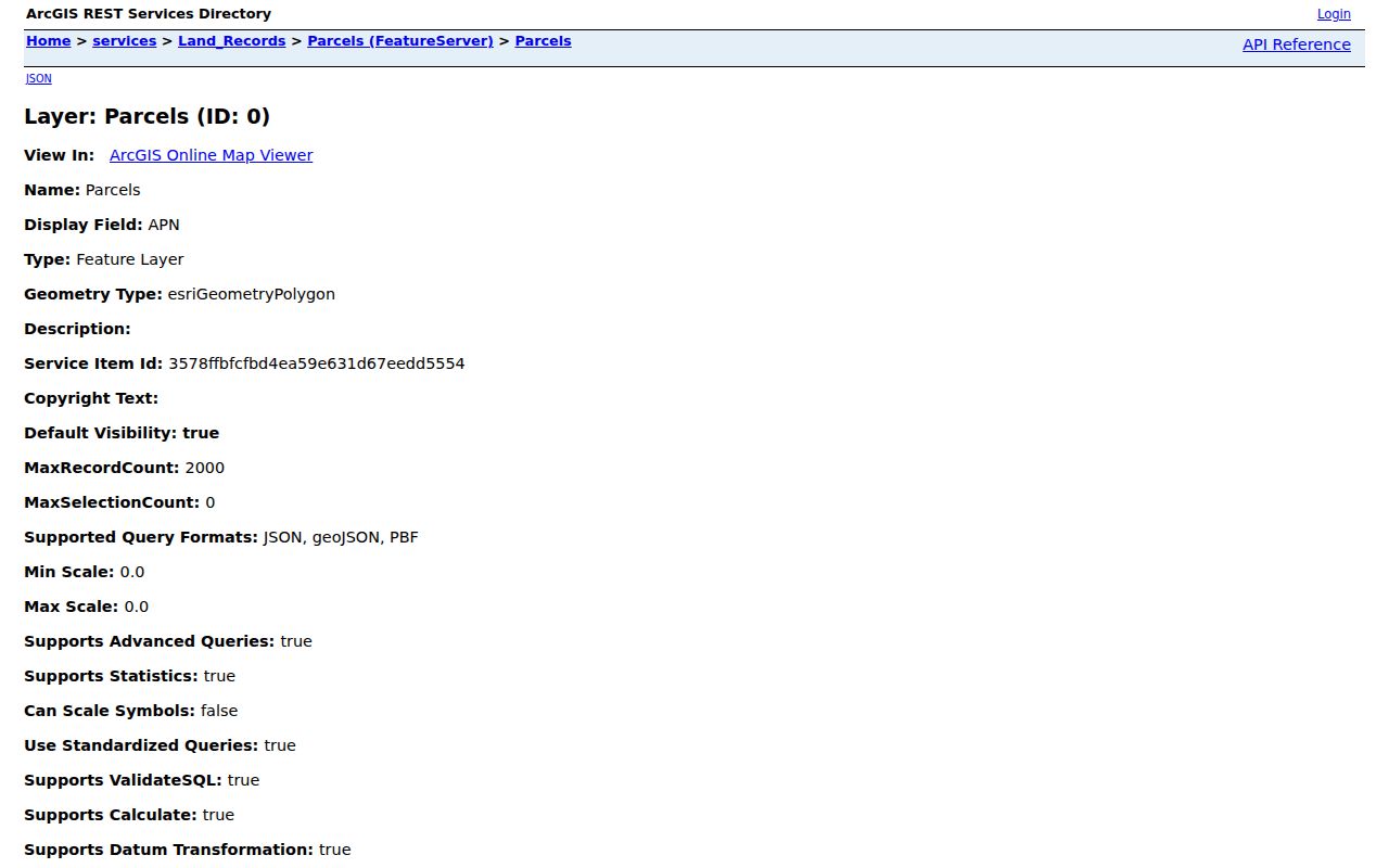
The visible parcel fields make it easier to explain why a Seaside APN is more useful than a loose street spelling when the research moves into deeds or permits.
Street-by-Street Seaside Records
A useful Seaside address directory combines address-keyed evidence without pretending that every source describes the same person. The assessment roll can identify an owner, the parcel layer can place the legal parcel, a deed can document a transfer, and a permit can date work at a permit address. Historical directories add occupants. Election records are a restricted channel, not a public street search.
| Record set | Custodian | Street value | Access |
|---|---|---|---|
| Seaside Parcel Report and GIS | Monterey County GIS | APN, parcel shape, legal and geographic context | Free map and layer |
| Seaside assessment roll | Monterey County Assessor | Owner, parcel status, values, exemptions, characteristics | APN inquiry, counter, data products |
| Seaside recorded instruments | Monterey County Recorder | Grantor, grantee, date, type, legal description, reference | Tyler and historical indexes; copies for a fee |
| Permits and code files | Seaside Building and Code Enforcement | Owner, applicant, contractor, permit address, work history when disclosable | Department channels or CPRA request |
| Directories | Monterey libraries | Historical occupant, spouse, occupation, and reverse address | Library shelf or microfilm |
| Voter information | California and Monterey Elections | Authorized residence and precinct data | Restricted under Elections Code |
There is no single public street-by-street roster behind this table. For Seaside records, the parcel number ties GIS context to the assessor and can help locate a deed, while the street name helps test the result against a directory. A person shown in a historical volume may have no title record, and a Seaside title holder may never appear as an occupant.
Seaside Situs, Mailing, and Legal Addresses
Three address terms can look alike in a Seaside property file but answer different questions. Situs is the physical location of the tax parcel. Mailing address is where a notice is sent and may point outside Seaside. Legal description identifies the lot, block, subdivision, or other recorded land description. An APN is the county parcel key. A by-address directory becomes more reliable when these labels are kept separate.
- Parcel
- A Seaside land unit identified by an APN and shown in the GIS layer.
- Situs address
- The Seaside physical place tied to the parcel, not proof of every person present there.
- Plat
- A recorded Seaside map or subdivision reference that helps explain parcel shape and legal description.
- Criss-cross directory
- An address-ordered historical directory section that can connect a Seaside street address to a printed occupant for its publication year.
The GIS service is explicitly not a survey. Recorded instruments and the official roll control a conflict about title or legal boundaries. This distinction is important in Seaside, where a familiar postal label can cross development eras and municipal contexts.
Seaside Deed Chain Without an Address Index
The Recorder search is a party and document index, not a dependable street browser. The current Tyler index at Monterey County Recorder reaches 1978 to the present and supports document number, type, date, book or reel and page, name, and map book or page modes. For a Seaside title trail, search the current owner as grantee, inspect the purchase deed, then search the seller as an earlier grantee. Preserve the instrument or reel and book/page, recording date, exact party spelling, and legal description at each step.
At the 1978 boundary, move to the historical Monterey index, which reaches 1850 through 1977. Older pages may require manual reel or alphabet browsing and spelling variants. The Recorder counter at 168 W. Alisal Street, First Floor, Salinas, is the fallback for viewing and copies. Published access charges are $2 per page, $2 per document for certification, and $5 per map page. A Seaside deed proves a title transfer. It does not prove every resident.
Seaside Street Permits and Code Files
Building and Code Enforcement can add a date and a public-record trail to an address. The department works from City Hall, 440 Harcourt Avenue. A Seaside permit file may include an owner, applicant, contractor, permit address, valuation, scope, and parcel information when the record is disclosable. Applications may go to the counter or to building@ci.seaside.ca.us; inspections use 831-899-6723, and code complaints use SeeClickFix or 831-899-6729. No verified public historical permit index was located.
The 2026 online InspectionRequest channel asks for 48 hours of lead time. Its weekday windows are 8:30 a.m. to noon and 1 to 4 p.m., with holidays excluded. For a Seaside request, use the City Clerk's CPRA channel for a focused existing record when a file is not available through the department. The request should name the address and record type, not ask the city to build a new street-by-street roster.
The Seaside Building and Code Enforcement source image here documents the address-based municipal channel. It helps distinguish a permit record from a title record or a household claim.
A permit can show work at a place. It cannot, without more evidence, show that the applicant owned or occupied the parcel.
Seaside Street Geography and ZIP 93955
ZIP 93955 crosses the core of Seaside and postal addresses in the former Fort Ord and CSUMB context. It is delivery geography, not an incorporated-boundary test. Seaside incorporated in 1954, while some older areas remained tied to Monterey and much of the shoreline went to Sand City. An address directory that relies on a postal city alone can therefore send a researcher to the wrong municipal custodian.
The official Seaside maps hub includes the adopted 2024 General Plan, zoning and coastal-zone maps, specific-plan maps, a Fort Ord buildings map, a historical Neighborhoods map, and older zoning maps. Compare that context with the APN, GIS jurisdiction, and legal description before filing a city request. No authoritative Seaside street-renumbering date was located, so an old spelling should be tested against deeds and maps rather than corrected by guesswork.
The Seaside maps source image below is a boundary and planning reference for Seaside street records. It is especially useful when a former-base address and an older city address share a postal label.
For a historical reverse-address shelf, the Seaside Directory Book page explains the Polk and Haines collections without treating a ZIP label as a city line.
Seaside Voter Files, Not a Street List
California My Voter Status is for a voter's own registration, polling place, and ballot-status check. For a Seaside street question, it is not a public name, street, or neighbor browser. A full voter file request is limited by Elections Code section 2194 to permitted purposes, and knowing unauthorized use is a misdemeanor under section 18109. The application requires an applicant and beneficiary, contact and organization details, a specific permitted purpose, scope, delivery choice, wet signature, certifications, and qualifying identification or institutional proof.
Monterey Elections is at 1441 Schilling Place, North Building, Salinas, with 831-796-1499. Historical Great Registers belong in library and archive channels, with exact reel years confirmed by staff. Safe at Home participants use a substitute address. These limits mean a lawful Seaside address directory should never promise a complete list of current households from voter data.
Limits of a Seaside Street Directory
Ownership is not occupancy in Seaside. A mailing address can belong to an absentee owner, and a historical directory is a publication-year snapshot. GIS does not settle a boundary, a deed does not name every resident, and a permit applicant is not necessarily the owner. Utility, delivery, and other customer records are not a public substitute. Protected voters and Safe at Home participants may be absent by design.
Lawful use. Seaside street and address records support personal, genealogical, estate, civic, and property research. Do not use a name, address, or map result to stalk, harass, intimidate, or harm a person. When a record conflicts or a living person's safety is involved, stop and ask the custodian about the proper lawful channel.